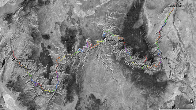
This website describes my solo traverse, below the rim, of the Grand Canyon. I completed this traverse in three section hikes. Excluding the hikes required to get to and away from the traverse route, my traverse totaled 526 miles and 47 days of hiking. The first section hike was done in the spring of 2016 and was 277 miles in length, just over halfway through the Canyon. That first hike was planned to be the entire traverse but a debilitated right knee forced my early return to civilization. The second section hike was done in the spring of 2018 and was 156 miles in length. My final section hike completed the traverse in the fall of 2018 and it was 128 miles in length.
There are often two or more ways to get from one point in the Canyon to another. When considering all the combinations of routes connecting all of those different points into a traverse, the number of possible traverse paths becomes large. My individual traverse route was dictated by many factors and was modified many times. I had to consider: my knowledge of the Canyon, my ignorance of the Canyon, the availability of water, food cache locations, the weather conditions, my goal to keep it nontechnical, escape routes, and generally being more cautious because I was solo hiking.
Why do such a traverse? For me, there were
a constellation of reasons to do it. But the seed for such a hike was
first planted in my mind in my early teens by Colin Fletcher when I
read his book “The Man Who Walked Through Time.” Like many
people, I have a fascination with the Canyon which draws me to visit
it relatively often. For this traverse, I was interested in going
places in the Canyon I had not been and places that are seldom
visited. I wanted to take in the Canyon's beauty from many more
perspectives. I was interested in more of an adventure than can be
had by sticking to well established trails. I was interested in
covering greater distances than the typical Canyon backpacking trip.
I wanted to hike in one direction long enough to see buttes and other
landmarks recede over the horizon behind me and marvel at what the
human body could do. I was drawn to the physical and mental
challenges it brought. That and more...
Before I started the traverse, I
wondered how my perspective of the Canyon would change after
completing it. Would the Canyon seem smaller afterward or larger than
I had perceived it? In the end, I came away with a better
appreciation for just how immense it really is and how little of it I
actually explored.
This was not typical Grand Canyon trail
hiking. All but 6 days were spent off trail. It was an exercise in
navigating across terrain riddled with canyons and ravines with
numerous smaller erosion features. This made hiking much slower,
more strenuous and, at times, even treacherous. However, when
erosion did not dominate, the terrain was pleasant to travel over.
The route had numerous different
obstacles. There were many places that required traversing on steep
loose talus slopes just above sheer cliffs. There were cliff bands
and pour offs that needed to be bypassed around or scrambled up or
down. Many ravines had steep, sometimes vertical, dirt and rock sides
that were both difficult to descend and ascend. There were places
with vegetation so dense and/or thorny that forward progress was all
but halted. In a number of silt flats in the far western end of the
Canyon, I spent more time walking on downed tamarisk trees than on
dirt. There were places where delicate steps and positioning were
required to traverse dense cactus groves to avoid contact. Many rocks
were fractured and eroded so hand- and footholds had to be tested
when scrambling or climbing. Contouring in the Canyon means a lot
time traversing dirt slopes with the higher foot pronated while the
lower foot is supinated. This used the muscles of my lower legs
differently than flat ground and resulted in an adjustment/training
period. A lot of time was spent in rocks or brush that made it
impossible to see rattlesnakes. I resigned myself to forging ahead
optimistically assuming a snake would not be in there (not always the
case). The off trail nature of the hike required more attention
because, with almost every step, there was an obstacle, large or
small, that had to be negotiated.
If you are interested, peruse the three
trip reports on this website. They contain a day-by-day account of
what I experienced, a map of each day's hike, some photographs, and
some beta for getting through each segment. There is a traverse
mileage page that contains a table where the distance and time
between campsites can be viewed. Finally, there is an acknowledgments
page for those who helped me accomplish the traverse and some of the
reference material I also used to plan my route.
Cheers,
Mark Egan


No comments:
Post a Comment